
- Stats: 402 0
- Posted: July 29, 2024
- Category: What To Do
Happy Trails: Favorite local hikes
After hiking the Appalachian Trail in 2014, Ashley UpChurch and Daniel Kreykes moved to the Gunnison Valley that December with dreams of rainbow-filled skies, heaps of backpacking trips and endless peaks to summit. In the intervening 10 years, they’ve climbed dozens of the Colorado 14ers, 33 and 54 respectively, and spent the summer of 2020 thru-hiking the Colorado Trail. Closer to home, they’ve backpacked all over the Gunnison watershed with a goal of hiking every trail they can find. In 2019, they both finished all 750+ trails outside of wilderness areas and are currently working on picking off all the wilderness trails. Here are a few of their hiking highlights in the north end of the valley.
Easy: Lower Cement Creek Trail Out-and-Back—3 miles round trip, 350’ elevation gain
First up is our go-to quick out-and-back with the pup, Lower Cement Creek Trail. Head down Highway 135 to Cement Creek Rd, about seven miles south of town, and drive a little over two miles to a pull-off parking area on the right. Take care as you drive along the dirt road—CB South residents often enjoy walks along this road, and bikers love it up here. The Lower Cement trailhead is on the left and starts right off the dirt road.
Throughout the summer, flowers of all kinds mingle with sage brush, aspen groves, and conifers, and it’s not uncommon to see a doe grazing with her fawns. Living in CB South ourselves, we’ve spent many an evening taking our cattledog, Sego, for an afterwork stroll along this beautiful trail.
Easy: Lost Lake Loop—2.5 miles round trip, 425’ elevation gain (counterclockwise)
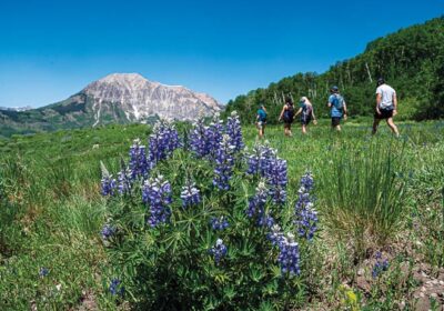
For a more remote option, head up Kebler Pass Rd from town for 16.5 miles until you reach the turn for Lost Lake Campground. Take a left here and drive another 2.5 miles towards the campground. You’ll find a parking area just before reaching the campground proper, where you’ll also reach the Lost Lake Trailhead. Grab your water bottle and your fishing pole and head off on this lovely 2.5 mile loop around the lake! While great any time in the summer or fall, Lost Lake is particularly fantastic for a fall foliage hike. The aspen groves all along Kebler Pass Rd are a sight to behold as they start exchanging their summer greens for fall reds, oranges, and golds.
Lost Lake Loop Bonus: Dollar Lake Trail Out and Back—1 mile round trip, 110’ elevation gain
While along the Lost Lake Loop, you’ll come to Dollar Lake Trail, which only adds another mile of hiking round trip. We highly recommend popping up to Dollar Lake, named for its nearly perfect round shape similar to a silver dollar.
Intermediate: Dark Canyon to Dyke Trail Loop—5.5 miles round trip, 1,500’ elevation gain (clockwise)
Sticking to the Kebler Pass area, the Dark Canyon to the Dyke Trail loop is a little closer to town, just 11 miles up Kebler Pass Road. You’ll access the trailhead at Horse Ranch Park, a right hand turn off Kebler coming from town. The Dark Canyon Trail takes you clockwise through one of the largest aspen groves in the nation and eventually connects with the Dyke Trail, which you could take out to the Lake Irwin area or back to your starting point.
As the name of the trailhead area suggests, you’re likely to encounter some horseback riders along this path. Keep in mind that bikers should yield to hikers and horses, and hikers should yield to horses. If you’re up for more adventure, check out the Latitude 40 Crested Butte-Aspen-Gunnison map for lots of backpacking options around the Dark Canyon and Dyke Trail area!
Intermediate: Gunsight Pass Trail to Copley Lake Out and Back—3.5 miles round trip, 1,000’ elevation gain
This was one of the first trails we explored when we moved to the Gunnison Valley. On a whim that we’re not likely to repeat any time soon, we climbed Gothic, Crested Butte and Red Lady in one day. With the sunset speeding us along, we didn’t venture out to Copley Lake that day, but we got back as quickly as we could.
The Copley Lake Trail is accessed off the Gunsight Pass Trail which starts from Kebler Pass Rd, just 4.3 miles from town. You’ll park in the pull-off lot on your left, cross the road, and head up the trail. Follow Gunsight Pass Trail uphill 1.5 miles until it intersects with Copley Pass Trail, then take this left hand turn for another quarter mile to the lake. Here we’ve watched coyotes hunting in the late-season snow and salamanders dancing in the shallow waters.
Advanced: Swampy Pass to Lowline Lollipop—14 miles, 2,500’ elevation gain (counterclockwise)
This is one of our favorite full day hikes or short overnights in the valley and one of the few backpacks we’ve returned to time and again. The trail starts at Swampy Pass Trailhead, 11 miles from Crested Butte via Kebler Pass Road to Ohio Creek Road. Swampy Pass Trail will take you over Swampy Pass itself and connect with Lowline Trail. Follow Lowline Trail to a gorgeous sweeping meadow where it intersects with Little Pass Creek Trail. Little Pass Creek Trail will take you back to Swampy Pass to complete the loop, and you’ll follow the rest of Swampy Pass Trail, the “stick” of the lollipop, back to your car.
Through the summer and fall, this loop has something to show off with the famous Castles rock formation as a centerpiece. In late June, runoff from the snowy peaks feeds vast fields of mule’s ear sunflowers, and in September, the aspen show off an equally vibrant yellow. With the Anthracites rising from one side and the Castles on the other, this loop will take your breath away on any given day.
Related Posts